Drain the ocean yourself: where you could walk 20,000 years ago
Lower the world ocean by just four metres and Sri Lanka becomes part of India. Lower it by 120 and you have put it back about where it stood 20,000 years ago.
Your seabed map
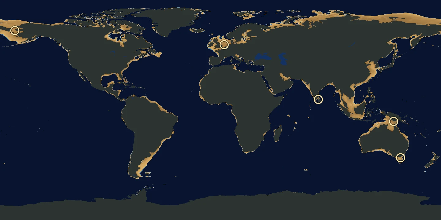
Move the slider or press −4, −12, −30, −44, −58 or −120 m and watch the seabed come out of the water. Without scripts there is a table of joinings below and the whole map at −120 m as a picture.
The ocean is lower than today by
exposed seabedshallow sea
Tap the map to read the depth at a point.
When islands and continents join
A joining depth is the smallest drop in sea level that opens a dry path between two points of land, computed on the ETOPO 2022 grid at 1′ (about 1.8 km). The map shows today’s seabed in 0.25° squares, so a narrow neck may appear on it a little earlier or later. Areas come from the 0.1° grid. The Black and Caspian Seas, the Great Lakes and Baikal keep their water on the map: we do not lower them. The Ice Age coastline differed from today’s seabed, which has since sunk, risen and filled with sediment.
| Sea level | What joins | Land gained |
|---|---|---|
| −4 m | Sri Lanka and India | 676,000 km² |
| −12 m | Australia and New Guinea | 2.2 million km² |
| −30.3 m | Britain and the continent | 6.2 million km² |
| −44 m | Asia and America | 9.3 million km² |
| −58 m | Tasmania and Australia | 12.3 million km² |
| −120 m | about the level of 20,000 years ago | 20.5 million km² |
What you are looking at
This is today's ocean floor, from ETOPO 2022, the global relief model of NOAA's National Centers for Environmental Information. Move the slider and the ocean drops a metre at a time, down to 130 metres. The seabed that comes out of the water turns to sand, brighter where it surfaced last. The sea still left stays blue, darker where it is deeper.
The first metres barely change the map of the world. Then the islands start to grow into the continents.
Bridges from the seabed
Four metres, and Sri Lanka is part of India. Twelve, and Australia and New Guinea are one land. At about thirty, Britain joins the continent: across the southern North Sea at 30.3 metres, through the Strait of Dover at 33.
Forty-four, and Asia joins America: the floor of the Bering Strait comes out of the water. At 58, Tasmania joins Australia.
Today's seabed holds more thresholds like these. Sakhalin joins the mainland at just 5 metres; Sumatra, Borneo and Java join Asia at 24, 34 and 45. Ireland joins Britain at 49.3, Taiwan joins China at 51, Sicily joins Italy at 99, and Kyushu reaches Korea only at 113.
Where the water went
Now press −120. The land gained is 20.5 million km², more than all of Russia, which covers 17.1 million. About this low stood the ocean 20,000 years ago.
Exactly how low is still argued over. Kurt Lambeck and colleagues (PNAS, 2014) find a slow fall to −134 metres between 29,000 and 21,000 years ago, deeper than the frequently cited −125. Yusuke Yokoyama and colleagues (Nature, 2018) place the low 20,500 years ago at about −125 to −130 metres. So: about 120 to 130 metres.
The water had not vanished: it lay on land as ice. Over the Hudson Bay region the Laurentide Ice Sheet is estimated to have reached a thickness on the order of three to four kilometres.
Then the ice began to melt. From about 16,500 to 8,200 years ago the ocean rose by an average of 12 metres every thousand years: a metre every eighty-odd years.
The way to America
At −44 the floor of the Bering Strait is dry, and Asia and America are one continent. People reached America from Northeast Asia through Beringia, the region on both sides of the strait.
How they went on is an open question. Along the Pacific coast, or inland through a corridor between the ice sheets? The evidence fits either route, and “neither can be rejected at present”, write Potter and colleagues (Science Advances, 2018).
Doggerland
Now slide to −31 and look at the North Sea. Between Britain and the continent a plain comes out of the water. It has a name: Doggerland. During the Ice Age, what is now the North Sea was land, “a large plain”, as the National Museum of Antiquities in Leiden puts it.
The sea took it back slowly. By around 6500 BC it had cut Britain off from the mainland, and the Dogger Bank, an upland of Doggerland, remained an island until at least 5000 BC.
Fishermen still know this plain. At the Brown Bank, about 50 nautical miles off IJmuiden in the Netherlands, the sea is only about twenty metres deep. When fishermen lower their dragnets, success is virtually guaranteed, writes Dick Mol in Deposits magazine: “Mammoth molars, tusks and large bones are abundant.”
And once fishermen found a piece of a human skull, south of the Eurogeul shipping channel off the Dutch coast. It is more than 13,000 years old: the earliest known human remains from the Netherlands. A bison bone decorated with a zigzag pattern, found south of the Brown Bank, is older still, about 13,500 years. It is the oldest art found in the North Sea.
Their land never went anywhere. It is under the sea.
How to read the map
The map is a grid of 0.25° squares. Each holds how far the ocean must fall for the square's mean depth to come out of the water. A joining depth is the smallest drop in sea level that opens a dry path between two points of land. We computed the five on the map on the ETOPO 2022 grid at 1′, about 1.8 km, so a narrow neck may appear on the map a little earlier or later; the other thresholds in the text were computed the same way and are not marked on the map. Areas come from points 0.1° apart. The Black and Caspian Seas, the Great Lakes and Baikal keep their water: only the world ocean is lowered.
Today's seabed is not the Ice Age coastline: it has since sunk, risen and filled with sediment. Tap the map to read the depth at a point. The Share button passes on only the slider position; the map itself makes no network requests and stores nothing.
Data: NOAA National Centers for Environmental Information, ETOPO 2022 15 Arc-Second Global Relief Model, doi:10.25921/fd45-gt74; under NOAA's terms it may be used and redistributed for free. Today's line between land and water: the NASA Black Marble VNP46A4 mask, with Natural Earth at the poles. NOAA and NASA took no part in this page and do not endorse it.
Sources & further reading
- NOAA NCEI, ETOPO 2022 15 Arc-Second Global Relief Model, doi:10.25921/fd45-gt74
- NOAA NCEI, ETOPO Global Relief Model (product page)
- NOAA CoastWatch ERDDAP, ETOPO_2022_v1_15s: description and terms of use
- Lambeck et al. 2014, Sea level and global ice volumes from the Last Glacial Maximum to the Holocene, PNAS 111, 15296–15303
- Yokoyama et al. 2018, Rapid glaciation and a two-step sea level plunge into the Last Glacial Maximum, Nature 559
- AntarcticGlaciers.org, Laurentide Ice Sheet at the Last Glacial Maximum
- Potter et al. 2018, Current evidence allows multiple models for the peopling of the Americas, Science Advances 4, eaat5473
- US National Park Service, Bering Land Bridge National Preserve: History & Culture
- Wikipedia: Beringia
- Wikipedia: Doggerland
- Dick Mol, Fossil bones from the North Sea, Deposits, 17 April 2021
- Rijksmuseum van Oudheden, Oldest human remains and oldest art from the North Sea, 9 February 2018
- Amkreutz et al. 2018, What lies beneath… Late Glacial human occupation of the submerged North Sea landscape, Antiquity 92
- Wikipedia: Russia — area 17,098,246 km²
- NASA, Black Marble
- Natural Earth, Terms of use (public domain)